

India is headed into a summer of compounding extremes. A fresh Western Disturbance is set to bring unseasonal rain to the north, an El Niño year threatens a weak monsoon and intensified heatwaves, and the humidity is already making temperatures feel far worse than the thermometer reads.
Western Disturbances are east-moving rain-bearing wind systems that originate beyond Afghanistan and Iran, and pick up moisture from the Mediterranean Sea, Black Sea, Caspian Sea and the Arabian Sea. These are typically extra-tropical cyclones resulting from low-pressure areas, formed by interactions between polar and tropical winds.
Western Disturbances are embedded within the subtropical westerly jet stream, which is a high-altitude, fast-moving air current that flows from west to east in the Earth’s atmosphere. It is found over the Himalayan and Tibetan highlands.
They are most common during the boreal winter months (December to March) and influence the weather over India, particularly the northwestern regions, as well as Pakistan, Afghanistan, and Tajikistan.
The year 2026 is being called an El Niño year. What does this mean?
To understand this, we must first understand what the El Niño South Oscillation, or ENSO means.
The El Niño Southern Oscillation (ENSO) is a climate phenomenon marked by changes in sea temperatures along the eastern Pacific Ocean, coupled with fluctuations in the overlying atmosphere. It can alter and interfere with the global atmospheric circulation, which, in turn, influences the weather worldwide.
Story continues below this ad
It has three phases: warm (El Niño, Spanish for little boy), cool (La Niña, Spanish for little girl), and neutral. It occurs in irregular cycles of 2 to 7 years.
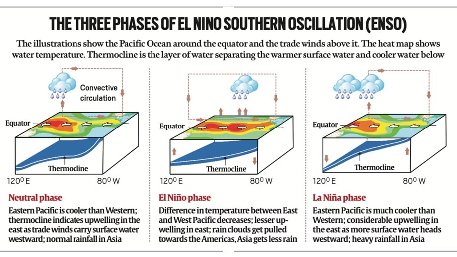 ENSO phases, explained.
In the neutral phase, the eastern side of the Pacific Ocean (near the northwestern coast of South America) is cooler than the western side (near the Philippines and Indonesia). This is due to the prevailing wind systems that move from east to west, sweeping the warmer surface waters towards the Indonesian coast. The relatively cooler waters from below come up to replace the displaced water.
During El Niño, the surface waters of this region of the Pacific get unusually warm, disrupting the flow of moist winds in India. The result is a weak or delayed monsoon for India, as well as dry spells in major agricultural states. There is also evidence that the frequency and severity of heatwaves India experiences are linked with the El Niño phenomenon. In April, the US Climate Prediction Center predicted a 61% chance of El Niño unfolding between May and July, and anticipates it will persist until the end of the year.
The opposite happens when La Niña is underway: cooling of the surface waters of the eastern Pacific. India thus gets stronger, moisture-bearing winds, and typically experiences a boost in its southwest monsoon. In extreme situations, the excessive rain has caused flooding and crop damage as well.
Story continues below this ad
We can expect to see more heat waves this year. What is a heat wave?
A heat wave is a period of unusually high temperatures departing from the normal, and varies from region to region depending on the historical temperatures observed in the region. It may be exacerbated by factors like high humidity (which we will dive into later), high wind speed and the duration of a heat wave event.
A heat wave may be considered if the maximum temperature of a station reaches 40°C in plains or 30°C in hilly areas. Once this threshold is reached, the IMD may declare a heat wave:
Based on departure from normal, meaning how much hotter it is than the usual temperature for that time of year. A heat wave may be declared if the temperature ranges 4.5°C to 6.4°C above normal, while a severe heat wave may be declared if it exceeds this upper limit.
Based on the actual maximum temperature. A heat wave is automatically declared if the actual maximum temperature reaches or exceeds 45°C, while a severe heat wave is declared if the actual maximum temperature reaches or exceeds 47°C.
Story continues below this ad
The agency follows slightly different criteria for coastal stations to factor in the humidity: If the maximum temperature reached is at least 37°C, a heat wave may be declared if the temperature departs 4.5°C from normal.
(These criteria must be met in at least two stations within a meteorological subdivision and must persist for two consecutive days. The official declaration happens on the second day.)
Speaking of humidity, what is a wet bulb temperature?
The temperature, as we know it and typically measured by a regular dry thermometer, is Dry Bulb Temperature. This value does not account for moisture. Wet Bulb Temperature, on the other hand, is the lowest temperature that can be realised by evaporating water into the air to measure how effectively humidity allows for evaporative cooling.
Quite simply, it tells you the maximum temperature your body can cool down to.
Story continues below this ad
Why this distinction? Besides heat, humidity has a major role to play in the physiological stress that the human body experiences during extreme heat. With increasing humidity, the sweat that humans generate to dispel heat from their bodies does not evaporate, making it difficult for a person to regulate their body temperature.
The Wet Bulb Temperature is usually lower than the Dry Bulb Temperature, with the difference increasing as the air becomes drier.
The Sixth Assessment Report (AR6), prepared by the Intergovernmental Panel on Climate Change (IPCC), says that sustained exposure to wet bulb temperatures exceeding 35°C could prove fatal, while sustained exposure to wet bulb temperatures exceeding 31°C is dangerous for intense physical activity. Especially at risk are people with pre-existing conditions (like heart disease or diabetes), as well as labourers who face an increased risk due to dehydration.
However, the likelihood of such temperatures being attained for more than a few hours is extremely unlikely, according to the AR6.
Story continues below this ad
And what does “feels like” temperature mean? Is it the same as Wet Bulb temperature?
No, the two are not the same.
“Feels like” temperature, or apparent temperature accounts for wind and humidity conditions to determine what the outdoor air temperature will feel like in relation to your body temperature.
For instance, a 40°C day in Delhi will not feel like a 40°C day in Palakkad, Kerala. Delhi experiences dry blistering heat with low humidity and dry, hot westerly winds, which still allows a person here to sweat relatively easily. In contrast, Palakkad experiences sticky, sultry heat with high humidity (ranging 60-70%), making it feel much hotter. The feels like temperature could be close to 45°C, making perspiration that much harder.
This distinction is an example of a heat index, a type of apparent temperature which measures how hot a human body feels when combining relative humidity with the actual temperature. Contrast this with wind chill index, another type of apparent temperature which combines temperature and wind speed. It measures how cold it actually “feels” on exposed skin as wind strips away the thin layer of warm air your body naturally produces to insulate itself.

